Thursday 30 November 2017

Indus water treaty -


The Indus Water Treaty (IWT) is a water-distribution treaty between India and Pakistan signed on September 19, 1960. The treaty was signed by the then Prime Minister Jawaharlal Nehru and Pakistan’s President Ayub Khan. It was brokered by the World Bank (International Bank for Reconstruction and Development).

Indus Waters Treaty (IWT): Simplified

Indus Water Treaty (IWT) The Indus Waters Treaty (IWT) deals with river Indus and its five tributaries, which are classified in 2 categories:

Eastern rivers:

  1. Sutlej
  2. Beas
  3. Ravi

Western rivers:

  1. Jhelum
  2. Chenab
  3. Indus
River Indus and its five main tributaries
  • According to treaty, all the water of eastern rivers shall be available for unrestricted use in India.
  • India should let unrestricted flow of water from western rivers to Pakistan.
  • It doesn’t mean that India can’t use western river’s water. The treaty says that India can use the water in western rivers in “non-consumptive” needs. Here non consumptive means we can use it for irrigation, storage and even for electricity production. (But India has not fully utilized this provision so far).
  • The treaty allocates 80% of water from the six-river Indus water system to Pakistan.
  • Permanent Indus Commissionwas set up as a bilateral commission to implement and manage the Treaty.
  • Though Indus originates from Tibet, China has been kept out of the Treaty.

India-Pak Disputes Connecting Indus: Timeline

  • 1948: India cuts off supply in most canals that went to Pakistan. But restores it later.
  • 1951: Pakistan accuses India of cutting water to many of its villages.
  • 1954: Word Bank comes up with a water-sharing formula for two countries.
  • 1960: Indus Waters Treaty signed.
  • 1970’s: India starts building hydropower projects in Kashmir. Pakistan raises concern.
  • 1984: Pakistan objects over India building Tulbul barrage on Jhelum. India stops it unilaterally.
  • 2007: Pakistan raises concern over Kishanganga hydroelectric plant.
  • 2008: Lashkar-e-Taiba starts campaign against India. Its chief Hafiz Saeed accuses India of water terrorism.
  • 2010: Pakistan accuses India of choking water supply consistently.
  • 2016: India reviews working of Indus Waters Treaty linking it with cross-border terrorism (Uri attack).

Why Indus Water Treaty in news?

Indus River
  • Indus Water Treaty is considered to be one of the most successful water-sharing endeavours in the world today. For 56 years, both India and Pakistan are peacefully sharing the water of Indus and its tributaries, thanks to The Indus Water Treaty (IWT).
  • Because of the confrontations between India and Pakistan over other issues, the water treaty naturally comes into picture.
  • After the Uri cross-border attack by Pakistan in 2016, Indian Prime Minister Narendra Modi had said “Blood and Water cannot flow simultaneously.”
  • There are issues between India and Pakistan, but there has been no fight over water after the Treaty was ratified. Most disagreements and disputes have been settled via legal procedures, provided for within the framework of the treaty.

Can India stop water flow to Pakistan?

Indus Water Treaty: Share of water to India and Pak

  • No. Not as per the treaty.
  • What India can do is to reduce the water flow to Pakistan by utilizing the provisions of the treaty.
  • But any project which may affect water flow will take time for implementation, considering the cost and objections involved. Pakistan has reportedly objected to five Indian hydro power projects, and the Wullar Barrage (Tulbul Navigation Project) which must be settled before India can resume work on them.

Can India walk out of the pact unilaterally?

The treaty has no provision for either country unilaterally walking out of the pact. Article XII of the treaty says “The provisions of this Treaty, or, the provisions of this Treaty as modified under the provisions of Paragraph (3), shall continue in force until terminated by a duly ratified treaty concluded for that purpose between the two governments.” Still if India wants to go about abrogating it, the country should abide by the 1969 Vienna convention on the law of treaties.

Had the Indian President signed the treaty?

The validity of the treaty is being challenged in court as it was signed by the Prime minister of India who is not head of the Indian republic. The President of India is the official head of the state.

Tulbul Project: By India

  • The Tulbul project is a “navigation lock-cum-control structure” at the mouth of the lake, located on the Jhelum river. It is a key intra-state channel to ferry state’s goods and people.
  • The idea is to ensure year-round navigation along the 20-km stretch from Anantnag to Srinagar and Baramulla, and on the 22 km-stretch between Sopore and Baramulla that becomes non-navigable in winter with water depth of only 2.5 ft (to sustain navigation through the year a minimum depth of water in the lake is necessary).
  • The project envisages water release from lake to maintain minimum draught of 4.5 feet in Jhelum.
  • India had started constructing a 439 feet long barrage at the lake’s mouth.
  • India unilaterally suspended the Tulbul project (Islamabad calls it Wullar Barrage) in 1987 after Pakistan objected.
  • The decision to review the suspension signalled the Modi government’s intent to revive it irrespective of Pakistan’s protests.
  • Implication: India gets to control Jhelum water, but that may impact Pakistan agriculture. The project can create problems for Pakistan’s triple-canal project that connects Jhelum-Chenab with Upper Bari Doab Canal. With a barrage, India controls release of water into Jhelum, which could trigger a flood or drought in POK and Pakistan.

Left Bank Outfall Drain (LBOD) Project: by Pakistan

  • Without taking consent from India, Pakistan has constructed Left Bank Outfall Drain (LBOD) project passing through the Great Rann of Kutch area (Gujarat, India) with the assistance from the world bank. The purpose of LBOD is to bypass the saline and polluted water which is not fit for agriculture use to reach sea via Rann of Kutch area without passing through its Indus delta.
  • The LBOD water is planned to join the sea via Sir Creek but LBOD water is entering Indian territory due to many breaches in its left bank caused by floods. Water released by the LBOD is enhancing the flooding in India and contaminating the quality of water bodies which are source of water to salt farms spread over vast area.
  • Gujarat state of India being the lower most riparian part of Indus basin, Pakistan is bound to provide all the details of engineering works taken up by Pakistan to India as per the provisions of the treaty and shall not proceed with the project works till the disagreements are settled by arbitration process.

Indus Water Treaty: Matters Beyond India and Pakistan

  • Indus originates from Tibet in China. If China decides to stop or change the flow of the river, it will affect both India and Pakistan.
  • Climate change is causing melting of ice in Tibetan plateau, which scientists believe will affect the river in future.

Should India violate a bilateral treaty with Pakistan because of cross-border attacks?

  • The Indus Water Treaty (IWT) was meant to reduce hostilities between India and Pakistan. It should be kept in the same spirit.
  • India has always dealt with security and water issues separately with Pakistan.
  • 80% of Pakistan’s 21.5 million hectares of farmland is irrigated by river Indus and its tributaries. Reducing the water flow to Pakistan will unleash havoc there (especially in Punjab and Sindh province).
  • Breaking the Indus Water Treaty doesn’t make any sense as India at present does not have enough infrastructure to use the additional water available. It may create flood in the Kashmir valley as well.
  • The decision of not giving water to Pakistan may further enrage the terror elements in the country, making them intensifying their attacks on India.
  • Not respecting the Indus Water Treaty, may invite global condemnation to India as the treaty is an international agreement.
  • Neighbours like Nepal and Bangladesh with whom we have water treaties may turn skeptical.
  • There are concerns that China may also block the water of Brahmaputra to Assam.
  • The Kashmir issue will get a whole new dimension if India withdraws from the treaty. Not only this, it would trigger the formal beginning of water wars
  • India, aspiring for a seat in the UNSC, should safeguard rather than violate bilateral treaties.
  • The approach of government should be to utilize provisions available in Indus Water Treaty itself. But building infrastructure across Indus will take time.

Summary

India has never used our rights on the western rivers. Under the Indus Water Treaty, we can make use of the waters of the western rivers for irrigation, storage, and even for producing electricity, in the manner specified. If we just do what we are entitled to under the Treaty, it would be enough to send jitters through Pakistan. It would be a strong signal without doing anything drastic.
Reference:


Wednesday 29 November 2017

RIVERS IN JAMMU AND KASHMIR


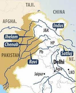
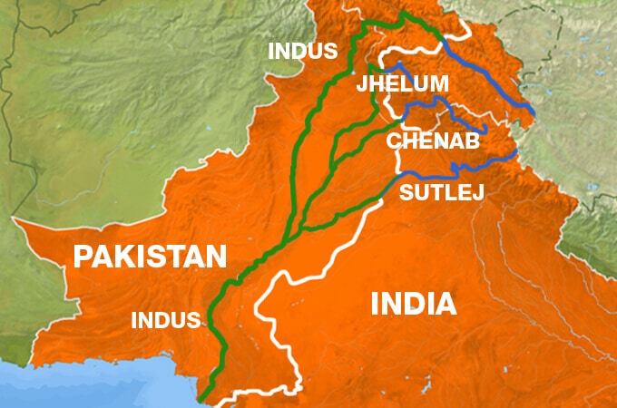
The State of Jammu and Kashmir has many lakes, rivers, and glaciers. Significant rivers that flow through the Jammu & Kashmir from the Himalaya are Jhelum, Chenab and Indus.
The major rivers in Jammu and Kashmir are :

  • Bringhi River
  • Chenab River
  • Chip Chap River
  • Doda River
  • Dras River
  •  Galwan River
  •  Indus River
  • Jhelum River
  •  Lidder River
  • Markha River 
  •  Nala Palkhu
  •  Neelum River,
  • Poonch River, 
  • Rambi Ara, 
  • Ravi River, 
  • Sandran River,
  • Shingo River, 
  • Shyok River, 
  • Sind River,
  •  Tawi River,
  •  Tsarap River,
  •  Ujh River,
  •  Veshaw River, 
  • Yapola River, 
  • Zanskar River


  • The Bringhi or Brengi River is a river in Jammu and Kashmir. It originates from the glaciers of Sinthan in Anantnag district. The river passes through a gorge at Daksum {altitude 2,438 m (7,999 ft)}.


Chenab River
Chenab River is one of the major rivers in Jammu and Kashmir. The Chenab is born through the confluence of two streams, namely the Chandra and Bhaga. This confluence occurs in Tandi, which is located within the upper Himalayas in Lahaul and Spiti district in Himachal Pradesh, at an elevation of 2,286 meters. The Chandra stream rises from South-East of Bara Lacha pass, while the Bhaga rises from North-West of Bara Lacha pass.

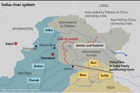
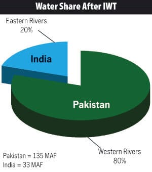
 In the upper reaches, the river is also known as the Chandrabhaga. The Chandrabhaga and Marau River join at Bhandera Kot, at a distance of 12 kilometers from the Kishtwar Town within Jammu and Kashmir. From here on it becomes the Chenab and courses through the Jammu region in Jammu and Kashmir. It flows into the Punjab plains of Pakistan devising the boundary between Rechna as well as Jech interfluves. The Chenab river actually means Moon River, with (Chan) signifying Moon and (aab) signifying river. The length of the Chenab River is estimated to be approximately 960 kilometers. The Chenab flows within Himachal for approximately 122 kilometers and has an impressive 61,000 square kilometers catchment area, of which approximately 7,500 square kilometers is located within Himachal Pradesh. The Jhelum River joins the Chenab River at Trimmu, following which the Chenab is also joined by Ravi River Ahmedpur Sial. After this the Chenab merges with Sutlej River at an area near Uch Sharif in Pakistan. The Panjnad or Five Rivers is formed with the inclusion of Beas River which joins Satluj River near Ferozepur in India. Finally the Chenab also joins Indus river at Mithankot. As per the terms of the Indus Water Treaty, the waters of Chenab have been allocated to Pakistan. Baglihar Dam also called Baglihar Hydroelectric Power Project was constructed in two phases on Chenab River in the southern Doda district. There was a great deal of design controversy, with Pakistain claiming that the project violated the terms of Indus Water Treaty. However, in 2010 all the related issues were amicably resolved. The Chenab River holds an important place in the life of people of Punjab and plays a crucial role in the iconic Heer Ranjha and Sohni Mahiwal tales.
Course
After the confluence of Chandra and Bhaga, the Chandrabhaga or Chenab flows northwest for approximately 46 kilometers, before receiving the first important tributary, Miyar Nalla. The Chenab continues in north-west direction for approximately 90 kilometers through Pangi valley in Himachal Pradesh and gains entry in the Padder region of the Doda district within Jammu. Continuing in north-west direction for a distance of approximately 56 kilometers, the Chenab is joined by Marusudar in Bhandalkot. It turns south at Bengawar, and then moves through a gorge across the Pir-Panjal range. It then enters a valley between the Dhauladhar and Pir-Panjal ranges. Flowing through the southern base of the ranges, the river flows up to Akhnoor and here it gains entry into the Sialkot area of Pakistan. The total length of the river from the Chandra and Bhaga confluence up to Akhnoor is approximately 504 kilometers.
Tributaries

The tributaries of the Chenab River include Miyar Nalla, Sohal, Thirot, Bhut Nalla, Marusudar and Lidrari. Marusudar is regarded as the biggest tributary of Chenab and joins Chenab in Bhandalkot. Kalnai, Neeru, Bichleri, Raghi and join the Chenab between Kishtwar and the Akhnoor region. Chenab is joined by Tawi as well as Manawar Tawi within Pakistan.

The Chip Chap River (meaning: "quiet river") flows from southern Xinjiang region of China to Jammu and Kashmir of India. It discharges into the Shyok River and is one of the upstream tributaries of the Indus River. Its basin area is around 4,410 square kilometers

The Doda River or the Stod River is a river 79 km (49 mi) long, which forms the Stod Valley in the Zanskar valley of the Ladakh region in the Indian state of Jammu and Kashmir. The Doda River rises from the Drang-Drung Glacier near Pensi La, a mountain pass of the Zanskar-Kargil road. The Drang-Drung Glacier is the largest glacier other than the Siachen Glacier in Ladakh outside the Karakoram Range. It gives rise to a mountain peak named "Doda Peak", 6,550 m (21,490 ft) high, and it is the namesake for the Doda district, which lies in the rear side of the glacier. After rising from its source, the Doda River flows southeast down along the Kargil - Zanskar road in the main Zanskar valley, through the towns of Akshu, Abran, Kushol and Phey. The river then passes a confluence with its tributary, the Tsarap River, at Padum. Together, these two rivers form the Zanskar River, a tributary of the Indus River. The Doda River contributes to the minimal agricultural production of the Zanskar valley by providing irrigation to the fields of barley, wheat, buckwheat and peas. Accessible in the summer, the Pensi La mountain pass at the source of the river receives heavy snowfall along with the other pass. Zojila cuts off the Stod Valley from the rest of the country during winter, and the river freezes during this season. The river source at Pensi La lies 350 km (220 mi) east from the Srinagar. The Doda River is famous for adventure sports. Rafting events are organised throughout the length of the Doda and the Zanskar.


The Dras River is a river in the Kargil district of Ladakh region, in the Indian state of Jammu and Kashmir. The Dras River is 86 km (53 mi) long and flows entirely in the Dras Valley. Its source lies in the Machoi Glacier near Zojila Pass, the gateway to Ladakh, 26 km (16 mi) east of Sonamarg and 120 km (75 mi) east of Srinagar. The Machoi Glacier is also the source of the Sind River, which flows through the neighbouring Kashmir Valley in the opposite direction to the Dras River. NH-1D, a national highway connecting Srinagar with Leh, runs parallel to the river. At Dras, it is joined by two tributaries, the Mashko Nala and Gamru Nala, which originate in the glaciers of Mashko Valley. In the Dras Valley, the road connecting Dras and Gurez, runs parallel to the river. The Shingo River joins the Dras River at Kharbu, and doubles the flow of the river. The Dras River joins the Suru River at Kharul, 7 km (4.3 mi) north of the town of Kargil. The Dras River flows through the towns of Matayan, Kharbu and Kakshar. The largest settlement on its banks is Dras, which is the second coldest inhabited place in the world after Siberia. The water flow of the river increases during the late summer, due to the heavy melting of glaciers.

INDUS RIVER  CLICK HERE


Jhelum river 

The Jhelum (Vyeth in Kashmiri, Vetesta in Sanskrit and Hydaspes in Greek) is the main waterway of the valley of Kashmir. It rises from a beautiful spring called Verinag. This spring is situated at the foot of a spur of the Pir Panjal mountain. Its total length is 725 km. The Jhelum flows to a distance of 25.6 km to Khanabal like a nullah. From that place a number of tributaries join the Jhelum and make it navigable from Khannabal to Wular Lake. Its total length in the valley is 177 km. It flows in loops through the valley till it enters the Wular; it flows out from its other side to Baramulla and then it enters the boundary of Pakistan. Srinagar town is situated on the either side of the river Jhelum. This enhances the beauty of the town making it a source of attraction for the tourists who stay in house-boats staying permanently in water on the banks of the river. 

Tributaries of the river Jhelum:
1. The Vishav is fed by the Kausarnag lake which is about 3 km long. It joins the Jhelum below Bijbehara. Kousarnag is at an elevation of about 4000 meters above sea level in the Pir Panjal Mountains to the south of Kashmir. Ice is present in the lake even in summer.

2. The Romushi is another tributary of the Jhelum. It flows from Kharmarg to Pakharpur and flowing towards north-east. It joins the Jhelum at 75 deg. East longitude.

3. The Dudhganga is another tributary of the Jhelum that flows from Ludurmarg and rises in the central Pir Panjal near Tata Kuti Mountain. Two mountain streams, the Sangesafed and the Yachera, form this river. This river flows through Batmalu Swamp near Srinagar.

4. The Sukhang is another important tributary. It rises near Gulmarg and irrigates a large area.

5. The Liddar is one of the largest tributaries of the Jhelum. It flows in a swift narrow stream from Sheeshnag Lake to the east of Pahalgam. The Liddar passes through many villages of which Mattan (Martand) is very famous. The Kolahai and Sheeshnag streamlets join the Liddar at Pahalgam to make it a river.

6. The Ferozpore Nullah is an important water-way in the western mountains of Baramulla-Gulmarg area. It collects water from many mountain streams, small lakes and springs. This mountainous area is mostly full of snow even in summer.

7. The Sind Nullah has its source in the Inner Himalayas at Dras and after it is fed by the Gangabal lake lying at Harmukh Mountain (5150 meters), it joins the Jhelum at Shadipur. It is 96 km in length. The famous health resorts of Sonamarg and Ganderbal are situated on its banks. Its water is used for irrigation purposes and the 'Sind Valley Hydroelectric Power Project' uses its water at Gandarbal to produce electric power. It is navigable from Gandarbal downwards.

Lidder, or Liddar, is a 73-kilometer-(45-mile-) long river in the Kashmir region of India in the state of Jammu and Kashmir. It originates from the Kolhoi Glacier and joins the Jehlum River at Gurnar Khanabal at an altitude of 1,615 m (5,299 ft). Lidder river originates from Kolhoi Glacier near Sonamarg and gives rise to Lidder Valley. It runs southwards through the alpine meadows of Lidderwat in region of Aru, from which it got its name. It covers 30 km (19 mi) before reaching Pahalgam where it joins the major tributary of East Lidder from Sheshnag Lake. It then runs westwards until it meets the Jehlum River at Gurnar Khanabal near Anantnag. It has crystal blueish water and Pahalgam is situated in the center of Lidder Valley. The waters of the river are mainly used for irrigation purpose through different canals and drinking through water treatment plants. There are many different varieties of fishes present in the river and a fisheries plant has been built on the banks of the river. 
Major types of fishes found in Lidder River are Brown trout (sulmo trutta fario) and Rainbow trout (sulmo gairdnri).


The Markha River is a river in Ladakh, India. It is a tributary of the Zanskar River. The Markha Valley is one of the most popular trekking routes in Ladakh, accessible from Ganda La pass near Spituk in the west, which is usually the beginning point of the trek, and Gongmaru La pass near Hemis, where the trek usually ends. On top of the valley you can find the Kang Yatze, a 6,400-metre-high (21,000 ft) mountain. The Markha River also passes to the south of the 6,153-metre-high (20,187 ft) Stok Kangri Mountain.


The Poonch River is a river in Jammu and Kashmir, India and Azad Kashmir in Pakistan. It originates in the western foothills of Pir Panjal range, in the areas of Neel-Kanth Gali and Jamian Gali. It is also called as Pulast River. It has two tributaries, Suran River and Betaar


The Rambi Ara is a river and major tributary to the River Jhelum located in Shopian district of the Indian controlled state of Jammu and Kashmir. It joins the Veshaw River near Sangam in Anantnag district before the confluence finally meets the Jhelum. The Rambi Ara originates in the Pir Panjal Range and has two major tributaries. The Rambi Ara is known for fluctuating water levels and is often affected by flash floods.

The Ravi River is a trans-boundary river crossing North-western India and Eastern Pakistan. It is one of six rivers of the Indus System in Punjab region (Punjab means "Five Rivers").The waters of Ravi are allocated to India under Indus Water Treaty. Under the Indus Waters Treaty of 1960, the waters of the Ravi and five other rivers are divided between India and Pakistan. Subsequently, the Indus Basin Project has been developed in Pakistan and many inter-basin water transfers, irrigation, hydro-powers and multipurpose projects have been built in India. The Ravi River, a trans-boundary river of India and Pakistan is an integral part of the Indus River Basin and forms the headwaters of the Indus basin. The waters of the Ravi River drain into the Arabian Sea (Indian Ocean) through the Indus River in Pakistan. The river rises in the Bara Bhangal, District Kangra in Himachal Pradesh, India. The river drains a total catchment area of 14,442 square kilometers (5,576 sq miles) in India after flowing for a length of 720 km (450 mi).

The Ravi River originates in the Himalayas in the Multhan tehsil of Kangra district of Himachal Pradesh, India. It follows a north-westerly course and is a perennial river. It is the smallest of the five Punjab rivers that rises from glacier fields at an elevation of 14,000 ft (4,300 m), on the southern side of the Mid-Himalayas. It flows through Barabhangal, Bara Bansu and Chamba districts. It flows in rapids in its initial reaches with boulders seen scattered in the bed of the river. The Ravi River in this reach flows in a gorge with a river bed slope of 183 feet per mile (34.7 m/km) and is mostly fed by snow melt, as this region lies in a rain shadow. Two of its major tributaries, the Buddhu and Mai or Dhona join 64 km (40 mi) downstream from its source. The Budhil River rises in Lahul range of hills and is sourced from the Manimahesh-Kailash Peak and the Manimahesh Lake, at an elevation of 4,080 m (13,390 ft), and both are Hindu pilgrimage sites. The entire length of Budhil is 72 km (45 mi) where it has a bed slope of 314 feet per mile (59.5 m/km). It flows through the ancient capital of Bharmwar, now known as Bharmour in Himachal Pradesh. The second tributary, the Mai, rises at Kali Debi pass, and flows for 48 km (30 mi), with a bed slope of 366 feet per mile (69.3 m/km), from its source at Trilokinath to its confluence with the Ravi.


The Shingo River is a tributary of the Suru River, and flows through the Ladakh region. It is created out of the confluence of Nakpo River as well as Marpo River which originates in Pakistan Administered Kashmir. The Shingo River enters India and meets the Dras River, coming from Dras. 5 km from Kargil the merged river meets the Suru River and again re-enters Pakistani territory.The Shingo River is clearer than other rivers in Ladakh because it is formed from melting ice.
The Shyok River runs across the northern areas of Ladakh and some parts of Pakistan (Ghanghche district) for approximately 550 km (340 mi). It is a major branch of the Indus River. The source of the Shyok River is the Rimo glacier. Major tributaries of the Shyok River are as follows:
The Galwan River
The Chang Chen Mo River
The Saltoro River
The Nubra River
The Sind River or the Sindh River is a river in the Ganderbal district of Jammu and Kashmir state of India. It is a major tributary of the Jehlum River and is 108 kilometers long. The Sind River forms the Sind Valley. The source of the river lies in Machoi Glacier at an elevation of 4,800 metres, east of Amarnath temple south of Zojila pass. It flows through Panjtarni (a camping site of Amarnath yatra) southwards up to Domail where it joins a tributary which doubles its flow from Kolhoi Glacier. It flows mostly westwards along with NH-1D and is fed by many glacial streams on its way to Ganderbal town. At Kichpora Preng it is fed by Wangath River which flows down from the Gangabal Lake. The major tributaries of the river are:
Amarnath stream
Kolhoi Grar
Shitkadi Nallah
Gund Nallah
Surfraw Nallah

The Tawi River originates from the lap of Kali Kundi glacier and adjoining area, southwest of Bhadarwah in Doda district. The catchment area of the river up to Indian border is 2168 km² and falls in the districts of Jammu, Udhampur and a small part of Doda. Elevation in the catchment varies between 400 and 4000 m. The flow of water in the river has been decreasing in recent years as the source glacier (Kali Kundi glacier) has been retreating. The length of Tawi River is about 141 km (88 mi). The river in general flows through steep hills on either side excepting the lower reach for about 35 km (22 mi). The river is about 300 m (980 ft) wide at the bridge in Jammu city. After passing through Jammu city, the river crosses into Pakistan's Punjab and joins Chenab River. Tawi is a major left bank tributary of river Chenab.


The Ujh River is the second most important river of the district Kathua. It rises from the Domal Structure of Seojdar of middle Himalayan ranges. The length of the river in the district is 65 km. And the average width is about 1.2 km. The main tributary of the Ujh river is Naaz and Bhinni Nullahs of Billawar. Ujh Barrage is constructed on this river at Village Jasrota. The water of Ujh River is utilized for drinking purposes. The River Ujh feeds a number of small canals and Khuls and its water is utilized for irrigation of agricultural land of the district. It also helps in transportation of timber from hills to plains in bulk besides of providing construction material like sand and stones, Ujh is a branch of Ravi River that comes from
Ramkot Fort side of Jammu, passes through
Kathua and enters Pakistan.
The Veshaw River or Nallah Veshaw is a major tributary to the River Jhelum located in Kulgam District in the Kashmir Valley of the Indian administered state of Jammu and Kashmir. It originates in the Pir Panjal Range and forms a waterfall at Aharbal.
The Yapola, also known as the Wanla River, is a river in Ladakh in Jammu and Kashmir. It flows into the Indus River near Lamayuru.

The Zanskar River is a north-flowing tributary of the Indus. In its upper reaches, the Zanskar has two main branches. First of these, the Doda River, has its source near the Pensi La {4,400 m (14,400 ft)} mountain-pass and flows south-eastwards along the main Zanskar valley leading towards Padum. The second branch is formed by two main tributaries known as Kargyag river, with its source near the Shingo-La {5,091 m (16,703 ft)}, and Tsarap river, with its source near the BaralachaLa. These two rivers unite below the village of Purne to form the Lungnak River (also known as the Lingti or Tsarap). The Lungnak River then flows northwestwards along a narrow gorge towards Zanskar’s central valley (locally known as Gzhung Khor), where it unites with the Doda river to form the main Zanskar river. This river then takes a northeastern course through the dramatic Zanskar Gorge until it joins the Indus near Nimmu in Ladakh.

 Arpat river : flows Southwest words originating from chor nag of district kashtwar....


___________Thanks 
Follow and like 


 Print Friendly and PDF

Tuesday 28 November 2017

Indian Geography In Brief : Topics To Cover


Indian Geography can be divided into three
1 Physical Geography,
2 Economic Geography
3 Social Geography.


The major sub-topics under Physical Indian Geography are Physio-graphic divisions, Drainage, Climate, Vegetation, Natural Resources etc. Topics related to environment like Wild-life, Soil, Flora etc should be given stress too. Economic and Social Geography related aspects of Indian Geography should the studied in parallel to Physical Geography.
Tip : NCERT Books will turn really handy for preparation of Economic and Social Geography.

Physio-graphic regions
1. Mountains (Himalayas).
2. Northern Plains.
3. Peninsular Plateau.
4. Coastal Plains.
5. Islands.
Drainage
1. Himalayan Rivers.
2. Peninsular Rivers.
Climate + Four Seasons of India
1. Hot Weather Season.
2. Advancing Monsoon.
3. Retreating Monsoon.
4. Cold Weather Season.
Vegetation
1. Tropical Rain-forest.
2. Tropical Deciduous Forests. (Monsoon Forests)
3. Mountain Vegetation.
4. Desert Vegetation.
5. Marshy land Vegetation.
Natural Resources
1. Minerals including Petroleum and Natural Gas.
2. Wild Life.
3. Forests.
4. Water.
5. Soil.

Human Geo: 

Economic Geography

Study in detail about the economic activities related to Agriculture, Industries and Services in different areas of India. Learn how the geography of a region affect the economic prosperity of the same.

Human Geo: Social Geography

Learn more the details like Demographics, poverty, hunger, literacy rates, unemployment etc. in a geography perspective.

Follow me https://www.Facebook.com/Aovious1
 Print Friendly and PDF

Autonomy of Parliament (In news)


@ http://www.Facebook.com/Aovious1

Significance: The winter session of the Parliament is postponed from its normal dates from the third week of November to mid-December this year. The delayed  winter session of Parliament will be held between December 15 to January 5. It will have 14 sittings over a duration of 22 days. The opposition parties had petitioned the President of India with respect to the issue.
About Parliament: The Parliament is the supreme legislative body of India. The Indian Parliament comprises of the President and the two Houses – RajyaSabha  and LokSabha. The President has the power to summon and prorogue either House of Parliament or to dissolve LokSabha. The Parliament is central to the very idea of democracy and was assigned a pivotal role in our Constitution by the founding fathers of the republic.
What Constitution says about sessions in the Parliament?: Article 85 of the Indian constitution says that the gap between two sessions of parliament should not be six months – which means the next session should be called before the completion of six months. It do not lay down any specific dates to begin or end the different sessions of the Parliament.
How the autonomy and significance of the Parliament is reduced over years?:
  • Criminalisation of politics: ADR reports that 34% of the MPs in the 2014 Lok Sabha faced criminal charges, as compared with 30% in 2009 and 24% in 2004. The ADR data also show that, across parties, candidates facing criminal charges were more than twice as likely to win as compared to those with a clean record.
  • Role of Accountability reduced:  It is the function of Parliament to exercise political and financial control over the Executive and to ensure parliamentary surveillance of administration. With the postponing of Parliament sessions, the accountability mechanism is disrupted.
  • Attendance: The presence of members of both Houses of Parliament – the LokSabha and the RajyaSabha – is central to their functioning.MPs are the extent of the media’s coverage of this important aspect of parliamentary functioning. On July 21, the RajyaSabha had to be adjourned without completing its business because of an insufficient number of MPs. The functioning of Parliament itself is put under question due to low attendance.
  • Legislation procedure:  Laws are often passed in rush with little scrutiny and no follow- up rules. In some cases, it takes sessions together for a bill to become law. Most of the bills are not passed to standing committees for further scrutiny nor put in public domain to have better policy development.Some of the laws are passed as money bills even if they do not qualify to be money bill.
  • Debate,discussion and dissent: These are the basic functions of the Parliament needed for a better governance and to ensure collective responsibility. However, often it does not happen as the number of days when the parliament meets and discusses the relevant issues have also gone down.
Reasons for the present state of the Parliament:
  • Overlap in priority: Most of the elected members of the party are busy in campaigning for the elections held in the state of Gujarat. The attempt by the executive to subvert the independent function of the legislature and its secretariat is unconstitutional.
  • Nexus between politicians and bureaucracy: The undesirable  relationship between bureaucracy and political leaders opened the door of criminalisation of politics. Also, inadequate legal mechanisms lead to promoting criminalisation of politics.
  • Inadequate penal mechanisms: encourage absenteeism in the Parliament and is a threat to effective parliamentary democracy. In fact , there are only 5 MPs clock 100% attendance in Lok Sabha.
  • People representative body to dynastic room: shift ownership of our Parliament from people to few entrenched dynastic oligarchs.Parliamentary hall is treated as drawing room of these oligarchs where everything is taken for granted without any code of conduct.
  • Emergence of regional parties and coalition politics: These lead to diversion of matters of high national and political importance to matters of regional importance and also lead to increased use of ordinance which subvert the legislature.
Conclusion: There are multiple threats affecting the functioning of Parliament. While we are justifiably concerned about the delay in the convening of parliament, we must also pay some attention to the slow process of subversion of the legislature by the executive which will break down the edifice of the legislature itself.


 Print Friendly and PDF

Monday 27 November 2017

National Strategy for Malnutrition Free India


©http://www.facebook.com/Aovious1

In news: NITI Ayog came with a national strategy to fight maternal and child malnutrition and anaemia among women and girls. The basis is that every third child of the country is undernourished which leads to several diseases, child death and maternal mortality.
Kuposhan mukt bharat (Malnutrition Free India) is the slogan given by PM and with this aim, the focus on 100 poor performing districts in terms of stunting is placed. The focus will be on decentralised planning and local innovation.
Recognising that India pays an income penalty of 9-10% due to a workforce stunted during childhood, the National Nutrition Strategy aims to bring nutrition to the centre-stage and remove all forms of malnutrition by 2030.
The strategy paper by NITI Ayog has to be a targeted approach which is monitorable and aims at
  • Reduction in the percentage of underweight below 5 from 35.7 at present to 20.7 by 2022.
  • Reduction in prevalence of anemia amongst children in age 6-59 months from current 58.4% to 19.5% by 2022.
  • Reduction in anemia among women in age group pf 15-49 years from 53.1% to 17.7%
Though these standards still lag behind from world standard, solid planning for achievement of all the goals has to be done. Several programmes under ICDS for food supplementation and anganwadis for children. Yet, we have not been able to overcome malnutrition.
  • Malnutrition child death can be prevented as soon as possible. When the women is pregnant, before the pregnancy, there can be a follow-up about common causes of death in women, how to conceive and what nutrition to take at time of pregnancy. There can be folic acid and iron supplementation for better nutrient intake. This can help to deliver a healthy baby.
  • Protein deficiency is a rare deficiency all over world and India is a protein deficiency country. The below poverty countries like Uganda, Columbia have combated malnutrition but India is still facing it.
  • Besides a medical doctor in PHC and CHC, there should be a social and preventive medicine doctor who can be good counsellor and help the pregnant women to fight malnutrition.
  • Aangawadi has good programmes but due to lack of coordination between them and PHCs, children tend to miss the necessary nutrient updates. If baby is healthy, the immunity will be strong. Comfortable to fight with the disease.
4 pillar strategy
  1. Improving health services
  2. Food
  3. Drinking water and sanitation
  4. Income and livelihood
Focus areas
Sanitation is a very important pillar of health sector. Vector borne disease can be prevented due to proper sanitation with regards to how to use food (boiled, cooked, not stale), how to store food (cover with lid), how to wash hands is very basic preventive techniques.
Most of air borne disease and vector borne disease can be prevented through proper hand wash practice.
Currently 50% of pregnant women and 60% of children in the country are estimated to be anaemic. The focus has been more on teenage girls and women who are anemic. If women is healthy, her child will also be healthy.
How to reach last man with polices like food security, swachh bharat, drinking water facility has to be still implemented with high success rate. There are people still left out from availing benefits from such policies. Proper laws can be made concerning nutrition, PPP mode can be entered to tackle the malnutrition challenges and support from civil society can help fight the grave issue. If the message is spread, it has to be taught too. It is not about just announcing programme but to teach the meaning of programme.
Communication is more important than information as it interacts with beneficiaries. And service is more important than communication as it shows the commitment to provide benefits that are communicated.
Infrastructure needs to be upgraded in terms of space, proximity to beneficiary and ease of access. Medical human resource should also be trained to focus on serving the nation where it is required the most. This points towards giving good health services to all people.

 Print Friendly and PDF

BLACK FUNGUS ?

  Explained: What is mucormycosis or ‘black fungus’ in Covid-19 patients, its symptoms and treatment Mucormycosis, a serious fungal infecti...